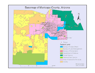
Summary of the process
1. Create a basemap showing county, places, and
federal land types.
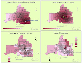
2. Select Chandler Regional Hospital and export.
3. Calculate distance around Chandler Regional
hospital.
4. Reclassify distance around hospital into nine
categories with an interval size of 10000.
5. Select Phoenix College and export.
6. Calculate distance around Phoenix College and
reclassify distance into nine categories with an
interval size of 10000.
7. Create a field and calculate percent of
population of 40 -49 using tract data.
8. Convert tracts to a raster with percentage of 40 -49.
9. Reclassify tract as a raster wih nine categories.
10. Download census tract data for Maricopa County, Arizona, from
11. Join to census tracts by FIPS
12. Convert tracts to a raster with median_value as the field
13. Using ModelBuilder, run two different weight overlays using the following parameters:
Fisrt weighted overlay
* Reclassed hospital: 25%
* Reclassed college: 25%
* Percentage 40 -49: 25%
* Median House value: 25%
Second weighted overlay
* Reclassed hospital: 40%
* Reclassed college: 40%
* Percentage 40 -49: 10%
* Median House Value: 10%
NB: It took several hours to download the census tracts data.


